SierraJourney

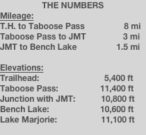
During the previous year, Cheryl’s brother Fitty wanted to explore the headwaters of the South Fork of the Kings River within Kings Canyon National Park. To do so, he hiked up and over Taboose Pass on the eastern crest and explored the areas of Bench Lake, Lake Marjorie, and Upper Basin. Having done this just once, Fitty vowed to never do it again. The Taboose Pass trail, even though it is “maintained”, is likely one of the most difficult passes on the East Side of the Sierras. You park your car at the trailhead in the desert where there is sand and sagebrush at 5,400 feet, start climbing through nearly every type of ecosystem that exists in the Sierras up a steep, rocky stream canyon, and reach the pass with snowfields and small ice-fed ponds at 11,300 feet. In summary, you climb nearly 6,000 feet in only 8 miles. The west side of Taboose Pass feels like a walk down the mall compared to the eastern approach.
During the Fourth of July weekend, we did just that. Our party consisted of my friends Keith and Terra, my brother-in-law Matt (a.k.a. Fitty), my wife, and a newbie to backpacking - my second cousin Gerrit. I warned Gerrit before the trip that this would be one of the most difficult trips that we had ever done, and would be even more difficult as an “intro to backpacking” trip. Funny thing was, at the end, he was the one leading the charge both up and down the pass. Darn young spry 18-year olds! The plan was to drive around the Sierras Thursday night and sleep in our cars at the trailhead, wake up early Friday morning and hike over Taboose Pass to Bench Lake, spend the next day hiking around the area and spending a second night at Bench Lake, and then head back to the trailhead on Sunday. Oh, and I promised Gerrit that we’d do a bunch of fishing at Bench Lake.
The first portion of the trail up to Taboose Pass is nothing spectacular, mainly following a creek (yes, it flows most of the time) through high desert terrain and vegetation. There are two stream crossings on the way up, which are the best places to fill up with water. The trail follows the stream more closely during the last third of the climb. The majority of the trail up to the pass is covered with rocks, nice double-fist-sized rocks that are difficult to walk on when carrying heavy packs. Being that this was a “training” trip for Cheryl and I since we were hiking the JMT later that month, we brought along many luxuries that we usually wouldn’t bring for merely a weekend trip, just to make our packs heavy.
For those that think they will not be able to make it over the pass in one day, there are only a few decent campsites along the trail on the way up. There really are not many flat, smooth spots near water to set up camp, so I’d recommend just pushing hard and getting over the pass. A whole different world awaits on the other side.
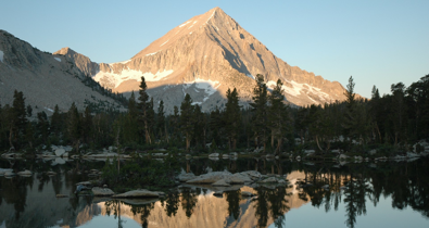
The pass is very broad and subtle, with small ponds and snow fields painting the scene. The view from here towards the west down to the South Fork of the Kings River is absolutely spectacular, especially if the lupine is flowering in the meadows just below the pass to the west. Eventually, the trail meets up with the John Muir Trail near the Bench Lake Ranger Station, which is about 2 miles from Ranger Lake and is merely a tent cabin. At this point, a couple of us were bonking. I was in the worse shape, and my buddy Keith wasn’t feeling so well either. Having just done the Climb to Kaiser road bike ride the weekend before, Keith told me that this hike was more difficult than that infamous ride. Wow, we sure picked a doozy, didn’t we?
Soon, we reached the marked junction with the spur trail to Bench Lake, and it was only an easy 1.5 miles to our camp on the shore of the lake. We stayed on the north shore of the lake, but great campsites abound at this lake. After setting up camp, Gerrit and I broke out our fishing poles and lured-up. I decided to try a yellow Panther Martin lure and had great success, easily catching my limit of 5, and all the trout were very good size (10 to 13 inches). To this day, I have used that lure (or its identical twins) for all my backcountry fishing. I called it my “Magic Lure” for the next year, until it got snagged on a rock at the bottom of Bench Lake the following year, when we visited again during our trip on the JMT. Luckily, I brought a bunch of identical spares incase my Magic Lure was lost. Anyway, to sum things up, Bench Lake is a great fishing lake. Interesting thing was that I caught three types of trout - rainbow, brook, and brown. I’m not sure which one is native, but I know that the USBR probably stocked fish at this lake via plane way back when.
The following day, we day hiked back to the JMT and up to Lake Marjorie. None of us wanted to hike very far that day, since we had to hike back to the car the next day. On the way back, I checked out a small meadow between the JMT and Bench Lake that the Kings River Water Association uses for their snow survey each winter. My friends at the KRWA heard I was heading to Bench Lake and asked that I take photos of the meadow. They were planning on coming up there later that summer to cut down some small trees to make it easier to land their helicopter to do their snow survey. I really hope I can be a guest in that helicopter some day...
We headed back to camp and enjoyed a leisurely day of swimming, napping, and, of course, fishing. Gerrit and I caught our limits again and we all enjoyed some awesome fish tacos, a special treat we later enjoyed on the JMT. Oh, and one more thing - the mosquitoes were awful! Thank goodness for nice tents to retreat to.
The hike back out the next day was uneventful, except for the fact that our knees learned how rocky and uneven the east side of the Taboose Pass trail is. Everyone wanted one thing and only one thing that day - to get back to the car and drop their pack! And the lower we got, the hotter it was. Near the end of the trail, I felt like I was in a movie, being someone wandering in the hot, sandy desert with a heavy pack on. We arrived back at the cars around mid-afternoon, pretty much the peak heat of the day. After driving down a fairly long dirt road back to HIghway 395, we headed off to Lone Pine for some awesome pizza at the Pizza Factory. We did the same thing a year later on the day we ended our JMT expedition.
Bench Lake is one of the finest camping destinations in all of the Sierras. Don’t just day hike to the lake - spend the night! If I could, I would build a cabin there and spend every summer at Bench Lake!
Bench Lake via Taboose Pass
7/4/08
As a training trip for the upcoming John Muir Trail adventure, Cheryl and I decided to take some friends over Taboose Pass to Bench Lake. Little did we know that this would be one of the most difficult trips of our lives. Good thing though - the shear difficulty keeps all the weekend wannabes out.