SierraJourney

Introduction
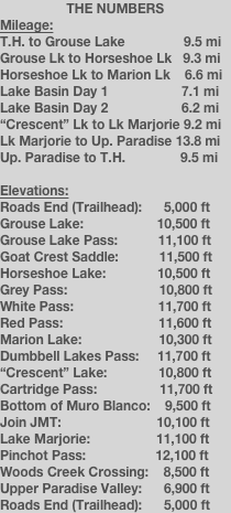
Before my wife Cheryl and I started planning for last year’s JMT trip, her brother Matt (a.k.a Fitty) developed the desire to somehow make it into this place called Lake Basin. Relatively unknown, even to backpacking enthusiasts (including myself, at first), this gem of the Sierras is extremely remote, yet incredibly beautiful. Lake Basin is located just west of Upper Basin (which is just south of Mather Pass), north of the infamous Muro Blanco along the South Fork of the Kings River, and south of Palisade Creek. The quickest way into the basin is via Taboose Pass on the east crest of the Sierras. In theory, you could probably get into the basin in less than 1.5 days via Taboose Pass and Cartridge Pass (which is just north of the South Fork of the Kings near the upstream end of the Muro Blanco). Crazy people may be able to do this in a day, but you will need a very light pack to have any energy left after climbing over Taboose.
However, the route Fitty and I traveled to get into Lake Basin took us 3 days to get into the basin, two of which were nearly completely off trail. Starting at Roads End in Cedar Grove (Kings Canyon), we took the Copper Creek Trail north up to Grouse Lake. From there, we headed off-trail over Grouse Lake Pass, Goat Crest Saddle, through Horseshoe Lakes, up and over Grey Pass, White Pass, and Red Pass, and finally dropped down to Marion Lake at the lower end of Lake Basin. This route is the southern portion of the Sierra High Route (SHR). This unofficial route, described by Steve Roper in his book Sierra High Route: Traversing Timberline Country (1982,1997), parallels (and is usually above) the JMT. However, the SHR is mostly cross country (it does utilize portions of the JMT) and was developed to minimize the need to descend into major creek and river canyons and waste all that energy needed to climb back out of them. Instead, the SHR traverses along high ridgelines and over “friendly” passes. Supposedly, nothing along the SHR is worse than Class 3. Read Roper’s book for more details on this awesome way to explore the Sierras. To tell you the truth, after hiking a portion of the SHR and the entire JMT, I am looking forward to hiking the rest of the SHR more so than doing the JMT again - there are just too many people on the JMT.
A Little History
Here’s a little history about Lake Basin before we begin. Back in the 1930s, the original JMT actually went through Lake Basin. The trail headed up Cartridge Creek from the Middle Fork of the Kings River, through Lake Basin, and out via Cartridge Pass. However, this portion of the JMT was abandoned in the late 1930s after the Golden Staircase was constructed below Palisade Lakes. So, for nearly 70 years, the trail through Lake Basin has nearly disappeared due to the lack of maintenance and relatively few visitors.
One of the first people to explore Lake Basin was Joseph LeConte (the person LeConte Canyon was named after) and his wife Helen Marion LeConte. They spent several summers near the turn of the century exploring the Kings Canyon portion of the Sierras. They used Marion Lake (he named the lake after her) as their base camp and they would venture out and explore such regions as the Palisades. They accessed Lake Basin by following the sheep trails up Cartridge Creek (yes, sheep trails, as in the trails sheep herders made to move their goats into Lake Basin during the summer - those are some tough sheep herders!). This lake was such a special place to both of them that the year after Marion died, Joseph went back up to the lake and place a plaque on a large boulder near the shoreline (see my photo).
But perhaps the most interesting tidbit of history is the expedition that the Sierra Club organized to bring nearly 100 (I think) people and mules into Lake Basin via the same route we took (Grey White, and Red Passes). They “built” a trail to follow into the basin, and we ended up following the portions of this trail that still remain. Wow, it’s amazing how much the Sierra Club has changed. Last year we learned they built a building on top of Muir Pass along the JMT, and this year we learned that they used to make their own trails. Makes you wonder why the Sierra Club exists now...
Day 1 - Friday 8-28-2009 - Roads End to Grouse Lake
Average HR = 134 BPM, Total Calories = 6,449
Elevation: 5,000 ft to 10,400 ft
Dinner: Pasta shells, mashed potatoes, and chicken
We got a late start today, leaving the trail head at 10 AM. Cheryl came up with us to wish us well on the trip. It’s just not the same without her. I almost feel like I don’t even want to backpack if she doesn’t go.
Today was to be one of the most difficult hikes I have ever done. It compares up there with Taboose Pass. I have hiked this trail before, but not this late in the day or while carrying 7.5 days of food. The last several miles were miserable. My legs were exhausted, I was getting light headed easily, I was recovering from a stressful week at work, and I only got 4.5 hours of sleep the night before. I was literally falling asleep when I took my breaks. I’m looking forward to 9 hours of sleep tonight.
We got our first taste of cross country today, leaving the Granite Basin “pass” to head to Grouse Lake. We arrived at the lake just before 6 PM. It’s a very quiet lake - the water is still, there is no wind, and I cannot hear water entering or exiting the lake. We didn’t have much time here, as it got dark around 7:30-8 PM. But dinner never tasted so good... A large cloud bank of smoke arrived over us around sunset, and came from the south. I hope it won’t take away from the views tomorrow. We’ll have a red moon tonight...
Day 2 - Saturday 8-29-2009 - Grouse Lake to Upper Horseshoe Lake
Average HR = 126 BPM, Total Calories = 6,552
8 AM - 5:30 PM
Dinner: Pasta noodles, chicken/corn/stuffing
Fortunately, we woke up to no major smoke like last night, but we could still smell it. All the mountains and canyons were hazy - I hope Lake Basin will be clear tomorrow. Nine hours of sleep was awesome - I finally felt pretty recharged except my body was still sore. We flew up Grouse Lake Pass and found our way up Goat Crest Saddle with no problems. Getting down the other side was a little more difficult, but not bad. At Goat Crest Saddle, I saw many landmarks I was familiar with: The Palisades, Taboose Pass, Arrow Peak, and the ridges above Pinchot Pass. What an awesome view! On our descent, we found the lower Glacier Lake to be quite pleasant and beautiful. The remainder of the hike was less spectacular, until we came to State Lakes (second lake was beautiful) and Horseshoe Lakes (we camped at the largest/northern lake).
Don’t get me wrong, but I miss hiking with Cheryl. It’s driving me nuts with her not being here. To me, Cheryl makes backpacking backpacking. I miss her so much!
My body is exhausted! My hip bones sting, my feet have blisters, my back hurts, my shoulders hurt - I’m just messed up. I think this is the hardest backpacking trip I’ve ever done in my life. Getting to Lake Basin tomorrow is my motivating factor right now.
Day 3 - Sunday 8-30-2009 - Upper Horseshoe Lake to Marion Lake
Average HR = 123 BPM, Calories = 5,975
8 AM - 5 PM
Weather: Cooler and windy, some monsoonal clouds
We woke up to fairly damp sleeping bags with ice. The morning warmed up fast, though. We did an excellent job of navigating the cross country terrain - we never had to back track due to a mistake. The Good Lord healed my body last night. My back felt stronger, my thighs hurt less, my feet are in less pain, and I finally feel acclimated to the altitude. Even though today was one of the shortest days mileage-wise, it was the slowest and most technically demanding. The only way I made it through all of today’s challenges was because the Lord carried me along.
The view from the Grey Pass South was awesome! We could see the backside of Spanish Mountain and Tehipite Dome. It was from this location that you could look straight up Goddard Creek Canyon and see a little of Enchanted Gorge, one of the most remote locations in the United States. I found a radio repeater antenna at the end of Windy Ridge - a good spot since you can also look straight up LeConte Canyon. The South Fork of Cartridge Creek was beautiful. Water seemed to be flowing everywhere and there were numerous lakes. The climb up to White Pass was pretty straight forward. We stayed to the right of the stream. The descent and ascent from White Pass to Red Pass was a little sketchy at times, but worked out well. The sketchiest part of today was the final 300-foot descent to Marion Lake. We followed a sand and rocky chute that appeared almost vertical. We thought we were in the left-most chute, but apparently there was another chute to our left that was better (according to the book, but after looking at this “better” chute, it didn’t look any better from the lake). Next time, we’ll try to stay to the left of the last large mound before descending.
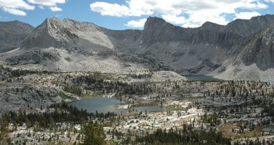
Marion Lake is beautiful - all the hype is legit! Awesome cliffs, high peaks, and beautiful shoreline surround the lake - I am glad we are staying two nights here.
I miss Cheryl terribly and wish she was here to enjoy this - I know she would! It’s just not the same without her - I kinda want this trip to end soon. We have been hiking with two other guys who are doing the same route (up to today, at least). One is Andy, a geology teacher for Spokane Community College. They will be heading over Frozen Lake Pass tomorrow, so we wish them good luck. We will be day hiking up to Dumbbell Pass (and maybe even the lakes)...
Day 4 - Monday 8-31-2009 - Marion Lake Layover - Hike to Dumbbell Pass
Average HR = 111 BPM, Calories = 4,736
Weather: Cooler, breezy, cloudy, but does not appear monsoonal or like thunderclouds. Clouds were over Central Valley too.
Dinner: Spanish rice w/ corn, mashed potatoes with chicken.
Cheryl, I miss you so much! It isn’t right, you not being here. This place is so beautiful - I want you to make it here someday. This place is God’s beautiful creation in its purest form. There are beautiful lakes everywhere, with incredible views of the mighty surrounding mountains. Claes Cliffout was clearly seen from all over the basin, and made me more homesick each time I looked at it. It was the only place here that Cheryl and I have been together, and reminds me of the best period of my life - hiking the JMT with my beautiful bride.
I had a lot of time to sit, enjoy the beautiful scenery, think, and pray. I did a lot of praying. I prayed to God to keep Fitty and I safe, healthy, and to make the right decisions. I prayed for Cheryl, that she would have energy to make it through the day and for her stomach to not irritate her. Finally, I prayed that our child will be strong and healthy, and that we will do nothing to compromise this. Being in a place like this just brings me closer to God. Finally, every step and path I took, I made sure it was safe, for I have two incredibly special people counting on that!
Okay, I have to vent, Fitty is the most anal person I have ever seen when it comes to dishes (and sanitation, for that matter). He would probably puke is he saw Cheryl and I do our backpacking dishes, but they are his dishes, and I’ll let him do it however he wants.
We hiked up to Dumbbell Lakes Pass in the morning. We knew we wouldn’t be able to make it down to the lakes and back because the clouds were forming early today (they didn’t turn into storms, but you never know). The ascent from our side was fine, but the other side looked bad. It was mainly large rock talus for probably 1,000 feet vertically. You may be able to avoid some if you stay to the hard left above the talus. I really have no desire to go down into Dumbbell Lakes Basin - Lake Basin is much better. The pass did provide a great view of the Palisades, however.
We explored and visited every lake in Lake Basin below the noticeable shelf above “L” Lake. Tomorrow, we plan on moving camp to one of the two lakes above this shelf - the highest lakes in the basin that have decent shelter. From there, we will explore (or try to) most of the lakes above the shelf.
Day 5 - Tuesday 9-1-2009 - Marion Lake to “Crescent” Lake
Average HR = 112 BPM, Calories = 2,296
Weather: Monsoonal-looking clouds overhead and to the east at 7 AM. Clouds developed slightly then burned away by mid-afternoon. Cooler and breezy.
Dinner: Asian noodles with vegetables, Lipton chicken rice with chicken.
Cheryl, I wish you were here! I am not enjoying this trip as much now - I’m ready to go home and be with my bride (and Duke, of course). We had a leisurely morning (left camp around 10 AM) and enjoyed a couple glasses of hot cider. We finally bid Marion Lake farewell. Oh, I forgot, there are really only 2 decent campsites at Marion Lake, and the ants are real bad. We left camp in search of a higher lake with decent shelter, so we could explore the lakes in the upper basin. We found a decent site at what we named “Crescent” Lake, which has incredible views of the surrounding peaks - perfect for sunset shots. I finally washed my clothes today (phew!), and we had a relaxing afternoon exploring the upper basin. We went as far up the basin as the second of the high three lakes, so we could get a small preview of the ascent up Cartridge Pass. It looks steep at first but will hopefully be okay. I think we visited nearly every lake in the upper basin - Fitty has video footage with commentary to prove it.
The two small lakes below “L” Lake have very large fish. We didn’t see much in the way of fish anywhere else in Lake Basin. I also saw a gardner snake crawl through my pants after I washed them and laid them on a rock to dry at “Crescent” Lake. Needless to say, I moved my clothes to safer ground. I’m pretty sure that the snake was more scared than me, perhaps never seeing a human before.
I’m feeling pretty good today, granted we didn’t move camp very far. Finally, our packs are getting lighter, and I think I estimated my food quantity okay. I’m going to put some dressing on two scabbed wounds on the backs of my ankles for tomorrow’s hike.
I’m looking forward to the hike up and down Cartridge Pass tomorrow. It will be interesting to find out how close Cheryl and I got to the base last year in Muro Blanco when we did the JMT. After getting down the pass tomorrow, all I will want to do is to get outta here and back to my bride - I think I’m spouse-sick. It will also be nice to see some other people on the hike back. Other than John and Andy (who we hiked “with” the first couple of days), we haven’t seen anyone else in Lake Basin. After our easy cross country travels all throughout the basin, I came to the conclusion that Fitty and I are the only ones in this magnificent place (unless someone is staying at Marion right now after descending Red Pass).
God sure has blessed me with the opportunity to visit such a place! But I’m ready to go home.
Day 6 - Wednesday 9-2-2009 - “Crescent” Lake to Lake Marjorie
Average HR = 124 BPM, Calories = 6,032
7:15 AM - 4:00 PM
Weather: Mostly cloudy by afternoon, breezy, some sprinkles, 1 clap of thunder, cool.
Dinner: Mashed potatoes with chicken, chicken noodles
At 2 AM, we both noticed quite a bit of clouds (with the help of the moon) that looked monsoonal. Needless to say, we didn’t sleep that well after that. We got an early start to get over Cartridge Pass in case storms were coming. The ascent was steep and loose, but doable. The descent to the lake was fine. This large lake had quite a bit of fish in it - worth a try if you camp there, of which there appeared to be plenty of flat spots to camp. The descent to the South Fork was unrelenting - incredibly steep and loose, but under tree cover. When we got to the bottom, I realized that Cheryl and I still had to hike about another 1/4 to 1/2 mile to get to the correct stream crossing last summer. When we reached the JMT, it was almost like culture shock. We came across five people, one being a ranger. He said to look for someone with a green daypack who had supposedly climbed Split Mountain and to send him to the ranger station (Bench Lake). We never saw him.
It was a stormy late afternoon at Lake Marjorie. It is cloudy, windy, drizzly (mainly sprinkles) and cold. We set the rainfly up tonight - it will help us keep dry and warmer. We had one clap of thunder, and the storm clouds appear to be fairly isolated (just so happens one is above our lake) and the clouds don’t move around. We found a nice campsite with a couple of trees and a rock wind wall (made by man).
I wish we could get out tomorrow, but it’s just too far - I miss you so much, Cheryl. I can’t wait to be with my bride! Being on such a familiar trail (fourth time in three years) without her feels so wrong. I’m looking forward to Labor Day weekend with her, and not Fitty (no offense, Fitty). It’s 7 PM and I am stuck in the tent with Fitty - good thing I have a pen!
Day 7 - Thursday 9-3-2009 - Lake Marjorie to Upper Paradise Valley
Average HR = 119 BPM, Calories = 5,541
7:30 AM - 4:30 PM
Weather: Like yesterday, clouds seemed to form earlier, some sprinkles at Upper Paradise.
Dinner: Garlic shells, stroganoff and lasagna Microwave Singles
Cheryl - we pushed hard today so we would be on time for sure at Hume tomorrow. All I can think about is seeing you (and giving you a big kiss). The phrase of the the day is “culture shock”. The climb over Pinchot Pass was quick, and we decided that if everything went well, we would push beyond Woods Creek Crossing (our original camp spot) to Upper Paradise Valley. This would shave over 5 miles of hiking tomorrow, making today the long day of the trip. As it was, we arrived at Woods Creek Crossing at 12:45 PM - way too early to set up camp. So we left there around 2:15 PM and arrived at Upper Paradise site #5 at around 4:30 PM. Interestingly, Woods Creek Crossing was nearly deserted (except for the occasional hiker coming through), so we didn’t know what to expect at Upper Paradise. Well, we found that the bridge over the South Fork is complete - Cheryl and I saw it being constructed when we did the Rae Lakes Loop in 2006. Sure enough, this area is packed with people. Luckily, there was an available camp site (only 6 legal sites at Upper Paradise). I don’t want to sound snobby, but the people here are not your typical JMT hikers. They talk like they know it all, have brand new gear they don’t know how to use, and get tired on the uphills very quickly. Oh well, I don’t care - 10 miles and we’re outta here.
It’s weird being camped at the end of Muro Blanco - we were at its beginning yesterday below Cartridge Pass. I have no desire to ever travel down the Muro - it will take days of bushwhacking - not what I want to spend my vacations doing. To tell you the truth, I’m not 100% sure I feel like going over Cartridge Pass again. But we’ll see.
I forgot to mention this earlier, but Mr. and Mrs. LeConte had it right. They made Marion Lake their base camp during the summers to explore the surrounding areas and peaks. They did it together (along with an assistant too). There is a monument/plaque on a large rock at the lake with her name on it. She died the year before the monument was made. What a way to spend your summers! I think they used the sheep herders trail to get up Cartridge Creek. What? Sheepherders went up there in the early 1900s? Modern people are wimps!
The Bench Lake ranger came to our site this morning and asked if we had seen someone else climb up in the area east of Lake Marjorie. We didn’t. He also said he hasn’t found the Split Mountain hiker. That ranger seems busy and stressed right now - no wonder.
Day 8 - Upper Paradise Valley to Roads End (and Hume for burgers!)
There’s not much to report on between Upper Paradise and the parking lot at Roads End. The face flies were incredibly annoying below 7,000 feet to the point of nearly going postal. I scared a rattle snake as a I walked by some granite slabs where the snake was sun bathing. And we literally reached the car just as the thunder began and it started down pouring. What an awesome way to end the trip! If it would have started raining even an hour earlier, it would have been even more miserable because it was so humid and warm.
Our timing for meeting Cheryl at Hume was perfect! Not more than 5 minutes after sitting down at a table, here comes my bride and Duke! Ah, my trip is finally over! This was one of the happiest moments in my life - we were together again! And now on to the Hume burgers!!!
Lake Basin via Sierra High Route
8/28/09
Cheryl and I were able to peak into this beautiful, secluded gem of the Sierras while hiking the JMT, but we found no easy way in. A year later, with her brother, we finally made it to one of the best vacation spots in the Sierras (if you like to literally get away from it all)!