Questions? Email Me
Yosemite Falls & North Dome Loop - Yosemite National Park
Distance
Net Elevation Gain
One Way Climbing Time
Overall Rating
My wife and I are trying to hike every day-hikable trail in the Yosemite Valley area. We have the done the whole Half Dome thing - twice, along with Cloud's Rest, a loop up the Four Mile Trail to Glacier Point and back down to the John Muir Trail passing by Illouette Falls, and Yosemite Falls/Yosemite Point numerous times. Thus, the only remaining serious hikes would be out to North Dome and the abandoned Sierra Point (hopefully spring of 2007). As a way of exploring the north rim of the Valley, I decided to try and make a day hike out of visiting Yosemite Falls, Yosemite Point, North Dome, and the headwaters of Snow Creek. A word to the wise: this is a very long day hike and you are bound to not come across any other day hikers midway through the hike. I have an addiction of planning ultra-long day hikes, and this is a great example. If you want to get away from the crowds but start in Yosemite Valley, this is the hike for you.
If you are reading this far into this story, you obviously don't need any description of the trail up to Yosemite Falls. If you haven't hiked to the top of Yosemite Falls before, try that before planning on doing this entire hike. Just as a basis of comparison, my wife and I started hiking at Camp 4 at 7:00 AM and made it to the top of Yosemite Falls by 9:20 AM (2 hours and 20 minutes). We arrived at MIrror Lake at the end of the hike at 5:30 PM (a total of 10.5 hours of hiking and rests). Be forewarned: even if you are feeling decent before you start the decent down Snow Creek's switchbacks, you won't when you reach Mirror Lake.
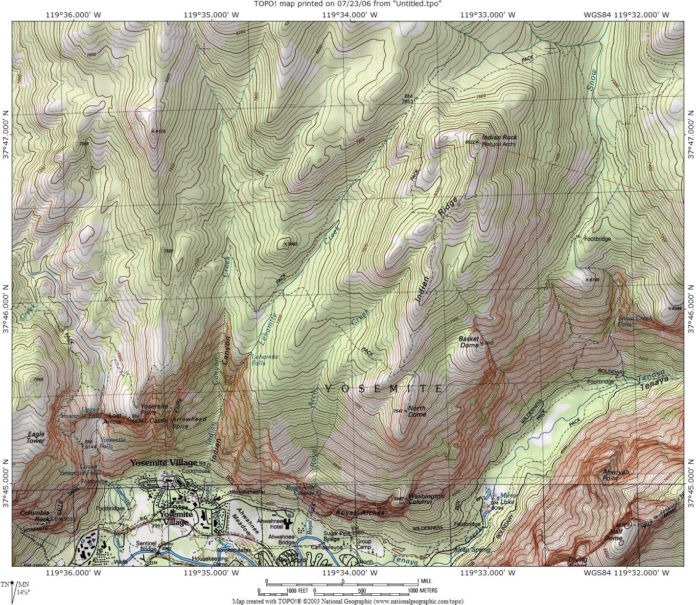
I'll start the trail description at the top of Yosemite Falls. Drop down to the bridge crossing Yosemite Creek and then take a short climb up to Yosemite Point. From here, continue east and into the forest and say good-bye to great views for about 1.5 hours, but you will cross three creeks (Indian Canyon Creek, Lehamite Creek, and Royal Arch Creek) which takes away from the mundaneness of this portion of the hike.
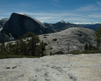
Continue on until the forest opens up and you begin to see North Dome for the first time. You will come upon a junction with a 1 mile-long spur trail that leads down to the top of North Dome. Be prepared to climb back up several hundred feet to reach this junction after visiting North Dome. With my cross-country hat on, I thought there must be a way to contour over to Basket Dome and decend while traveling north to eventually reach Snow Creek. I'm not too sure if this is a smart (safe) idea or even possible hike, but it's something to think about as it will cut out some distance from the hike.
As you leave North Dome, the trail follows Indian Ridge where you can take a spur trail up to Indian Rock, a natural arch. We were not sure how long it would take us to finish the hike (more on that in "About the Hike"), so we skipped that side trip since we could see it from the main trail. The trail continues to circumnavigate the mountain Indian Rock is on and drops down into the creek on the north facing slope. You will then meet up with the main tributary of Snow Creek and head south toward the Valley.
After decending for a while, you will come to a junction with a trail leading over a bridge and up to Olmstead Point along Tioga Pass Road. This would be the last convinient place to fill up on water before you reach Mirror Lake. Shortly after this, the great decent begins back into the Valley. Make sure your knees and feet are ready for one of the most grueling decents I have ever done in my life. I guarantee this will be the longest 3 miles below 7,000 feet you will ever do - even while going down. Eventually, after complaining and thinking of greasy pizza and soda, you will reach the junction with the trail that leads back to Mirrow Lake. The frustrating thing is that it's still almost a mile to the nearest shuttle stop once you reach Mirror Lake, and walking on asphalt will be the last thing your feet want to do.
You better not be tired when you reach the top of Yosemite Falls. The hike up until this point should be just a stretching exercise because, mileage-wise, the hike has just begun. Take in the views from Yosemite Falls and Point because you will just see pines and firs for the next 1.5 hours or so. You will most likely see no humans either, unless they camped somewhere between Yosemite Point and North Dome. We hiked this trail on June 3, 2006, and there was a significant amount of water in each of the three creeks we had to cross. The only creek I had to take my waterproof boots off for was Indian Canyon Creek. I would imagine these creeks would be dry by August since I believe most of the water is from melting snow and not from springs, so plan your water filtering stops accordingly.
The climb up Indian Ridge from North Dome started taking us into some snow. We came across two backpackers just before North Dome that were going to take the same path as us back to Mirror Lake. They told us that a ranger said there was a significant amount of snow on the trail on the north facing slope of the Indian Rock mountain. There was enough snow by the time we met the junction at upper Lehamite Creek for us to completely lose the trail. We were able to occasionally follow footsteps and tree blazes, but we relied mainly on our topo map to get us down to the main tributary of Snow Creek. Once we reach the east facing slope of the mounting, the snow quickly dissapeared.
I recommend you take a break near the bridge over Snow Creek before the infamous decent down Snow Creek's switchbacks. While traveling down, we can across several dads taking their 10 year old (plus or minus) sons on a backpacking trip up to the top of the switchbacks. Apparently, they had started hiking around 11 AM (we came across then around 3:45 PM and they still had about 1 hour left at their current pace). This is an excelent way to make your son hate backpacking, especially for first-timers.
Anyway, we saw a California king snake about 2/3 of the way down, which is not suprising since the majority of the trail is in the sun and is very rocks. So, beware of rattlers even though we did not see any. The remainder of the hike was, well, to say the least, very frustrating and all I could think about was taking the shuttle back to Yosemite Village and eating from greasy pizza and soda.
We didn't see any established campsites along this trail, but that's not saying you couldn't camp somewhere along this hike if you wanted to make it into a backpacking trip. I would recommend camping near one of the first two creeks you have to cross between Yosemite Point and North Dome for easy access to water.
If time permits, I would recommend trying to hike up to Indian Rock arch. For all I know, it might be a dissapointment after visiting Arches National Park, but it appears to be a short and easy jaunt off the main trail.
The junction at upper Lehamite Creek is only 1.6 miles from Tioga Road, so a day hike beginning at Tioga Road would make a relatively flat and short hike to North Dome.